World Wetlands Day.. How the occupation destroyed the natural wealth of Ahwaz?
On World Wetlands Day, which falls on February 2nd each year and carries the theme of ‘Restoring our Wetlands’ this year, to highlight the importance of wetlands for sustaining life on the planet and addressing the effects of climate change.
The wetlands of the Ahwaz region include marshes, water catchment areas, natural and artificial lakes, permanent or temporary wetlands with fresh, slightly brackish or salty water in the form of standing or flowing.
Wetlands are some of the most important natural ecosystems on the planet, which have long played an important role in the development of the societies around them. The many benefits of wetlands include protecting and supporting biodiversity, providing food and other wetland products, and providing facilities and educational opportunities, making them among the most important and valuable ecosystems in the world for the conservation of biological and cultural diversity.
The wetlands of the Arab country of Ahwaz are, in fact, holes saturated with surface or groundwater; Therefore, they are seen along or along the banks of rivers.
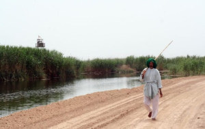
In these wetlands, there are groups of flora and fauna that are specific to this type of environment. The wetlands of Ahwaz are very important in terms of influencing climate and economy, and they are always suitable habitats for wildlife, especially because of their water reserves and peace. Wetlands are very important in terms of flood control, groundwater recharge, recreational facilities, research areas and bird hunting.
The most prominent wetlands in Ahwaz
One of the most prominent wetlands in the state of Ahwaz is the Falahiah wetland lake in the area between the city of Khormosi and the city of Al-Falahiah, with an area of 4,000 square kilometers. Its waters are sweet and flow from the Jharari River and its branches, the winter rains and the Gulf currents of the Persian Gulf. There are 70,000 hectares of these wetlands under protection and control like wildlife.
And Lake Tempe, Ohu Hor “Tembe”, this lake is located one hundred kilometers north of the Suleiman Mosque and on Mount Kino.
Lake “Bamdaj” is a wetland of about 40 square kilometers 40 kilometers north of Ahwaz between the Karkheh and Darz rivers, which are fed by the Shahour River.
And Al-Hour Al-Azm – a wetland, which is also called Hor Al-Hawizeh, located in the western part of the state of Al-Ahwaz in the border areas between Iran and Iraq, between the Karkheh and Tigris rivers, and is fed by the Karkheh River and streams east of the Tigris River, and its waters overflow in the Tigris and Shatt Al-Arab rivers, its area ranges from between 4,500 and 56,000 km² (Madari et al., 2005: 34-33).
Persian occupation and destruction of the wetlands
Environmental reports have warned that the wetlands and rivers in the occupied Arab state of Al-Ahwaz are threatened with drought due to the lack of water resources and the high level of salinity due to the construction of the “Jamsheer” dam on the rivers of Al-Ahwaz, to transport water into the Persian interior.
In the new geological studies, 60% of the bed of the “Jamsheer” dam lake is exposed to salinity, and a salt outcrop was discovered near the Ahwaz rivers in the vicinity of the dam.
The rate of precipitation has decreased and groundwater extraction has increased in the main branches in recent years, and the issue of dissolving salt and chalk layers in the dam’s reservoir may not lead to an increase in salinity.
In addition, the presence of 11 oil wells in and around the perimeter of the dam has unexpected environmental risks.
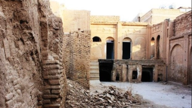
The city of Ithij is also witnessing environmental deterioration. In a Persian plan, in order to convert wetlands and forests into residential lands, Persian settlers are being brought to Al-Ahwaz.
The Izh watershed is located along the Zagros mountain range in the north-east of the Arab state of Ahwaz. The annual rainfall in this basin is more than 200 mm.
The Ige wetland is one of the most important habitats for waterfowl and water-side migratory birds in the province, so that every year thousands of migratory birds migrate to this wetland to spend the winter.
The Myangaran Wetland, which has an area of about 1,256 hectares in the rainy season and 380 hectares in the summer, is located 1.5 km north of Ige between 47.49 degrees east longitude and north latitude.
The maximum depth of Mingaran in the high water seasons is estimated to be 3.5 metres, and the average depth is 1.75 metres. The main sources of water supply in these wetlands are rain water and surface water
Views of environmental change can be seen by glimpsing mountains, mountains with shaved faces, lakes and valleys burnt into residential lands.
Environmental reports indicate that the Persian occupation has destroyed nature in Izh, and also in the mountainous areas and villages in this city has increased the death rate there.
Among the most prominent causes of pollution and environmental change in Izh, the discharge of urban sewage and sewage from the slaughterhouse of Izh, as well as the entry of agricultural liquid waste containing fertilizers and chemical toxins into the waters of these wetlands, and the drainage and drying of wetlands, and the use of lands obtained by the Persian settlers is considered The proximity of wetlands to urban centers is among the most important threat factors.
And since the studies that have been conducted so far in order to investigate and understand the environmental status of these wetlands are very few and limited, therefore comprehensive studies and research in this regard are very necessary and noticeable.
Izh forests and wet areas also witnessed several cases of fires, which led to the loss of thousands of hectares.
At the same time, Al-Ahuz suffers from many problems due to climatic changes and global warming, such as the increase in fine dust and the destruction of wetlands.